
Neighbourhood Traffic Calming Plan
Consultation has concluded
Creating safer roads - traffic calming pilot coming to select neighbourhoods
The City of Vaughan is creating safer roads through the Neighbourhood Traffic Calming Plan, also known as the Neighbourhood Area Traffic Calming Policy, Design and Speed Management Plan. This project is one of the major road safety initiatives identified under MoveSmart – the City’s Mobility Management Strategy.
Now that the City has a stronger sense of which tools are best fit for Vaughan, a new draft traffic calming toolbox has been developed. The goal of this toolbox is to help the City address road safety concerns and ensure appropriate traffic calming and speed management approaches are integrated into new and existing roads in Vaughan.
Five neighbourhoods have been selected to pilot the new toolbox. Appropriate traffic calming and speed management approaches will be carefully selected, temporarily installed and actively monitored in each pilot neighbourhood to test their efficacy. Learn more about the five pilot neighbourhoods:
- New Kleinberg (Ward 1)
- Sonoma Heights (Ward 2)
- Vellore Village (Ward 3)
- Carrville Corners (Ward 4)
- Lakeview Estates (Ward 5)
What is traffic calming?
Traffic calming refers to physical features and road designs intended to reduce vehicular speeds as well as the number and severity of collisions, improve pedestrian and cyclist safety as well as the quality of the environment, and potentially reduce traffic volumes.
Traffic calming can take many forms to slow down vehicular speed and create safer roads. This can include the development or installation of curb and sidewalk extensions, roundabouts, narrowed roads, raised crosswalks at intersections, pavement markings, flexi-posts or streetscaping.
Phase 1 Public Consultation
An online survey closed Feb. 13 and included questions about improving livability and road safety in Vaughan neighbourhoods, reviewing options for various traffic calming measures and more.
An online mapping activity also closed Feb. 13 and was an exercise meant to identify specific areas in Vaughan where you may see or experience issues related to traffic calming and speed management.
Phase 2 Public Consultation
A short online survey and interactive map closed June 14 and offered an opportunity to identify roads or intersections where traffic-related concerns are taking place and where specific traffic calming measures might be installed.
A series of virtual open houses were held for each community for residents to learn more about the project and its expected outcomes.
A series of walking tours/design workshops were held for each community for residents to walk the neighbourhood, see where potential measures will be implemented, discuss design options and speak with members of the project team.
-
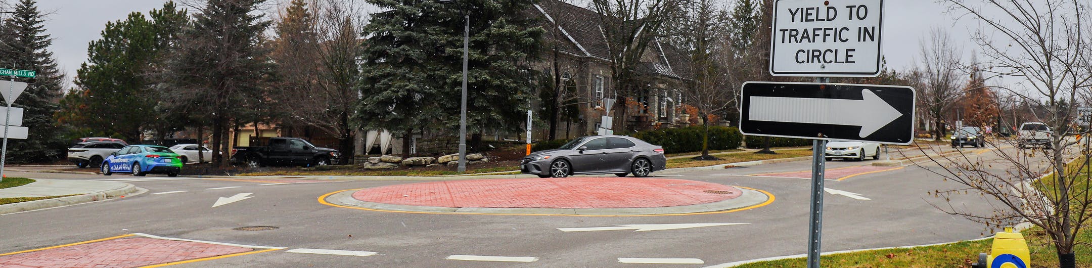
Neighbourhood Traffic Circles
Share Neighbourhood Traffic Circles on Facebook Share Neighbourhood Traffic Circles on Twitter Share Neighbourhood Traffic Circles on Linkedin Email Neighbourhood Traffic Circles linkNeighbourhood traffic circles are installed at the intersections of local streets within residential areas. Neighbourhood traffic circles are intended to keep the speed to a minimum and increase safety at minor intersection crossings. Vehicles and cyclists entering the roundabout must yield to pedestrians crossing the crosswalk and circulating traffic.


Application/Considerations/Outcomes
- Applicable on roads with less than 1,500 vehicles per day and should be avoided at intersections with high pedestrian volumes
- Appropriate for local and collector street intersections
- Include marked crosswalks to clarify where pedestrians are crossing
- Provide yield control for motor vehicles
- Provide about 5 metres of clearance from the corner to the widest point on the circle
- In case landscaping is planned – sightlines should be respected
- Shared lane markings or intersection crossing markings should be used to guide cyclists through the intersection
- Crosswalks should be marked to clarify pedestrian crossing points and that they have priority
- Approximately 4.5m of clearance from the corner to the widest point on the circle should be provided to reduce traffic speeds
- Restricted access for trucks and longer school buses
- Resulted in reductions in speeds of up to 12 km/h (Source: U.S. Department of Transportation Federal Highway Administration)
- Automobile accidents have been reduced by 94% (Source: Mundell, J., n.d.)
Image sources: NACTO, City of Vaughan
-
Continuous Sidewalks
Share Continuous Sidewalks on Facebook Share Continuous Sidewalks on Twitter Share Continuous Sidewalks on Linkedin Email Continuous Sidewalks linkContinuous sidewalk and/or cycle track designs maintain the surface for the sidewalk at the same heigh across side street intersections and driveways, bringing the roadway up to the level of the sidewalk rather than having the sidewalk drop down to the level of the road. This creates a clear priority for people walking and cycling at these intersections while also creating elevation changes that encourage slower turning behaviours for drivers.


Application/Considerations/Outcomes
- Can be placed at an intersection where a major street intersects with a smaller residential street
- Sidewalk material and color does not change as it crosses through the intersection
- Roadway curb continues parallel to the street, resulting in no defined turning path for motor vehicles
- The roadway ramps up to the crossing, encouraging drivers to slow down
- Corner radii can be designed at a 90° angle, forcing drivers to slow down as they make a right turn
Image sources: Roy Simons, ISL, Google Earth, Ottawa
-
Centreline Bollards/Flex Bollards
Share Centreline Bollards/Flex Bollards on Facebook Share Centreline Bollards/Flex Bollards on Twitter Share Centreline Bollards/Flex Bollards on Linkedin Email Centreline Bollards/Flex Bollards linkCentreline bollards, also known as vertical centreline treatment, places vertical installations on the roadway to create a centre median. This treatment gives an illusion that the roadway is narrowed and constricted, encouraging drivers to reduce their speed.


Application/Considerations/Outcomes
- Apply to two-lane local and collector streets
- Avoid areas that may block driveways or cross street access and transit services
- May be applied in conjunction with speed cushions
- May require more detailed maintenance considerations
- Fairly low-cost and easy to implement
- Can help to reduce collisions between traffic lanes due to increased separation
- Can result in decreases in 85th percentile speeds up to 5 km/hr (TAC Canadian Guide to Traffic Calming, 2017)
Image sources: Town of Newmarket, City of Greater Sudbury
-
Dynamic Speed Sign
Share Dynamic Speed Sign on Facebook Share Dynamic Speed Sign on Twitter Share Dynamic Speed Sign on Linkedin Email Dynamic Speed Sign linkA dynamic speed sign is a traffic calming device designed to slow down drivers by alerting their travel speed as they approach the area. These signs alert the drivers that exceed the posted speed by flashing their speed, encouraging the drivers to reduce their speed. Dynamic speed signs may be installed on either a permanent or a rotating basis.


Application/Considerations/Outcomes
- Appropriate for all roadway classifications
- Apply along mid-block locations; avoid locations where the sign may distract driver’s attention from pedestrian crossings or intersections
- May be applied to school zone areas or construction zones
- May be applied in addition to, or in place of, other traffic calming measures
- May be applied in locations where criteria for physical traffic calming interventions are not met
- Average speed may be reduced by 6 km/h in areas with a dynamic speed sign. In one United Kingdom study, crashes decreased from 3.2 personal injury crashes per year to 1.5 at one site and from 0.7 to 0 in another site (Source: Winnett, M. A. and A. H. Wheeler. Vehicle Activated Signs—A Large Scale Evaluation. Road Safety Division, Department for Transport, 2002)
Image sources: Google Maps, Toronto, City of Hamilton
-
Diverters (Modal Filter)
Share Diverters (Modal Filter) on Facebook Share Diverters (Modal Filter) on Twitter Share Diverters (Modal Filter) on Linkedin Email Diverters (Modal Filter) linkA diverter is a raised barrier placed diagonally across an intersection that forces traffic to turn and prevents traffic from proceeding straight through the intersection. Diverters can incorporate gaps for pedestrians, wheelchairs and bicycles and can be mountable by emergency vehicles.
Diverters can also be implemented as a directional closure at an intersection – restricting through movements on a local street through a curb extension or physical barrier on the far side of the intersection.


Application/Considerations/Outcomes
- Appropriate for local and collector streets
- Design should permit passage by emergency vehicles through mountable elements
- Can be unsatisfactory to through cyclists who may be exposed to unsuspecting traffic on both sides of the diverter (depending on the diverter geometry and cyclist manoeuvre)
- Can be implemented as a part of overall network policy or comprehensive system (limited use can cause traffic to shift to another street or neighbourhood)
- Proven to be most successful when combined with two or more measures
Image sources: Google Maps, Hamilton, Wikimedia Commons Credit: Richard Drdull
-
Speed Table (Raised Crossing)
Share Speed Table (Raised Crossing) on Facebook Share Speed Table (Raised Crossing) on Twitter Share Speed Table (Raised Crossing) on Linkedin Email Speed Table (Raised Crossing) linkA speed table is a raised section of a road, similar to a speed hump, but longer and flat-topped.

Application/Considerations/Outcomes
- Appropriate for local and collector streets
- Can also be designed as raised midblock crossings (often in conjunction with curb extensions)
- If it coincides with a crossing or crosswalk, it should be designed as a raised crosswalk
- The slope of a speed table should be between 1:10 and 1:25 and side slopes on tapers should be less than 1:6
- The vertical lip should be less than a 0.6 cm high
- May require additional maintenance responsibilities
- May help to highlight and define speed tables for pedestrians and cyclists
- Should not be applied on streets more 5 m wide
- Can be applied in both directions on two-way streets
Image source: NACTO
-
Raised Median Island (Median Refuge Island)
Share Raised Median Island (Median Refuge Island) on Facebook Share Raised Median Island (Median Refuge Island) on Twitter Share Raised Median Island (Median Refuge Island) on Linkedin Email Raised Median Island (Median Refuge Island) linkA raised median island is a protected median in the centre of a two-way street, designed to reduce the overall width of the adjacent travel lanes and provide a safe space for cyclists and pedestrians to cross the road.


Application/Considerations/Outcomes
- Appropriate for local, collector, and urban arterial streets
- Can be used as a traffic calming device without crossings for pedestrians and cyclists
- Installed where a cycling facility crosses a moderate to high volume or high-speed streets
- Streets with high pedestrian / cyclist volumes and a lack of safe crossing opportunities
- At signalized or unsignalized intersections
- A median can act as a diverter to prevent cut-through traffic on a bicycle facility
Image sources: NACTO
-
Truck Apron
Share Truck Apron on Facebook Share Truck Apron on Twitter Share Truck Apron on Linkedin Email Truck Apron linkCurb radii at intersection corners are designed to accommodate all vehicle types. Typically, many intersection corners are designed for larger vehicles, which enables smaller vehicles to turn at a higher speed than desired. Truck apron is a mountable curb alignment to reduce turning speeds for smaller vehicles. Meanwhile, this treatment accommodates a larger corner radius to allow larger vehicles to go over the truck apron when making right turns. The design of the truck apron should discourage pedestrians and cyclists to use them as a safe queuing area.


Application/Considerations/Outcomes
- Should be visually distinct from the adjacent travel lane, sidewalk and bike facility
- Height of the mountable areas and curbs should not exceed 3 inches above the travel lane
Image sources: Maricopa Association of Governments and Alta Planning + Design
-
Curb Extensions
Share Curb Extensions on Facebook Share Curb Extensions on Twitter Share Curb Extensions on Linkedin Email Curb Extensions linkA curb extension is a horizontal intrusion of the curb into the roadway, resulting in a narrower road section. Curb extensions increase pedestrian visibility for drivers and improve sight lines for pedestrians. As a result, pedestrians experience shorter crossing distances and drivers are required to slow down. Curb extensions can also create parking bays, narrowing the street and expanding the availability of on-street parking.


Application/Considerations/Outcomes
- Appropriate for local, collector, and urban arterial streets
- May interrupt bike lanes
- May reduce on-street parking
- May impact intersection operations through the reduction of lane provision
- Reduced turning radii may impact emergency service vehicles and larger vehicles turning at the intersections
- Potential damage to the curb during snow removal operations
- Increased snow removal costs and operation time
- Drainage system adjustments and utility relocations, such as utility poles and fire hydrants, may be required to accommodate roadway narrowing
- Adequate clear sight triangles should be maintained within the curb extension; obstructions such as vegetation overgrowth and landscaping should not limit the sight distance at intersections
Image sources: NACTO
-
Intersection Centreline Hardening
Share Intersection Centreline Hardening on Facebook Share Intersection Centreline Hardening on Twitter Share Intersection Centreline Hardening on Linkedin Email Intersection Centreline Hardening linkIntersection centreline hardening is the placement of bollards or rubber/concrete curbs to prevent drivers from cutting across intersections at a diagonal.


Application/Considerations/Outcomes
- Appropriate for busy streets to reduce conflicts between pedestrians/cyclists and motor vehicles
- Can be combined with a protected-permissive bike signal phasing
- Centreline hardening force drivers to turn slowly at a right angle
- Can decrease vehicle and pedestrian conflicts by 70% (Source: Insurance Institute for Highway Safety)
Image sources: Insurance Institute for Highway Safety, City of Toronto

Follow project

For more project information visit vaughan.ca/NeighbourhoodPlan

Who's listening
-

Email Sari.Liem@vaughan.ca -

Email Sadia.Khan@vaughan.ca -

Email Justin.Jones.2@wsp.com